|
The Most
Advanced Flight Planners Available!
 What's new in
version 3.0?
What's new in
version 3.0?
Welcome to 21st century flight planning with the most modern
and
easiest to use flight planners.
Voyager SmartPlan Premier and Express
are the most modern, easiest to
use flight planners on the market at any price. Powerful features like the
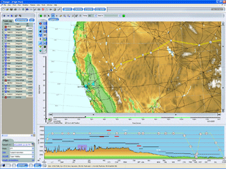
true 3D wind-optimized SmartRouter?,
high-performance aircraft modeling, integrated
satellite and radar overlays
and seamless Internet
connectivity
get you from planning to flying in record time.
Voyager's SmartPlan
is the only flight planner available that recommends a
different route each time you plan based on the weather and
winds aloft specific to your departure time, destination, and
the aircraft you fly. Only the true 3D wind-optimizing
SmartRouter can take you on a different path every time and
save you time and fuel costs.
|

The smart step-up from free flight planners. Ideal for occasional flying.
|

The most advanced flight planner made.
For high-performance, IFR or frequent flying.
|
|
The essential
tools you need for planning safe flights:
-
Free hourly TFR
updates
-
Basic weather: SmartWeather graphical
depiction of National Weather Service reports: METARs/TAFs and Winds
Aloft
-
Premium weather with Annual Subscription: Radar and
Satellite overlays and ultra-fast Winds Aloft downloads
-
Full DUATS area
and route briefings with local and FDC NOTAMs and PIREPs
-
Extensive printed trip kits,
kneeboard or full page
- Data kept current automatically in the background
through your Internet connection
- Sectional and enroute IFR charts and data
- Airport and runway info, elevation, nav and comm frequencies
(requires Annual Subscription to remain current)
- SmartRouter - true 3-D, wind optimized autorouting that
minimizes time not distance
- File and print FAA flight plans
- Licensed
for installation on three PCs (e.g. home computer,
work computer, laptop or Tablet PC).
- One month of Update Subscription service as described
below
|
Same as Express, plus the following added features:
-
Profiling for
high-performance piston, turbo, turbine and jet aircraft,
for all weights and temperatures
-
Profile view
shows flight over terrain, airspace, airway MEAs and cloud layers
- Autorouting for best time or best economy
- SIDs and STARs integrated into autorouting
- All US IFR instrument Procedures and airport diagrams,
always kept current for free
- Extensive FBO information with AOPA membership
- ICAO or FAA flight plans filed electronically
- File flight plans by leg or as a complete flight
- Totally customizable printing and Chart views
-
Export to the Garmin handhelds 296, 295, 196, etc.
-
Export to the Lowrance AirMap 500/1000/2000c
-
Export to
Anywhere Map
-
Export to Microsoft Flight Simulator. Fly the route
virtually before you go, with real time weather!
|
 Voyager Update Subscription Voyager Update Subscription
We
strongly recommend this subscription service for safe flight
planning. It provides you with three valuable services
for a full year:
Monthly navigational data updates
- US (incl. AK and HI), Canadian and Mexican navigational
databases revised by the FAA and DoD (DAFIF) every 28 days.
This includes airspace, airport information, airways, navaids,
etc.
- Downloaded automatically from the Internet
Premium weather
New product versions
|
|